Utility Survey:
Utility Survey Mapping Utilities, Services & Apparatus
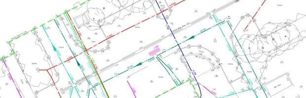
Underground Utility Mapping enables all buried services and utilities to be detected and mapped. Our surveys can show full horizontal and vertical (depth of cover) positioning on all detected buried utilities and anomalies, including plastic, fibre-optic and clay drainage pipes which means;
detection, location and mapping of:
- electric
- gas
- water
- communications including fibre optic
Our surveys can be as focussed as a routing study for an individual pipe through to a blanket survey of an entire site/development area. Underground Mapping techniques are used on a wide variety of sites and environment including:
- town centres/highways
- factories/plants
- sewage & water treatment works
- power stations (coal, gas & nuclear)
- electrical substations
- gas terminals
"Managing the avoidance of underground hazards begins at the earliest stage of design and continues all the way through a project to filing the as-built drawings" - National Grid 2007.
The absence of service plans should not be taken as proof that the area is free of underground services/apparatus. Unless strong evidence suggests otherwise, the presence of services and utilities must be expected.